|
04 december 00
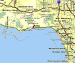
the beat is on me Every map tells a story... ~~~ "Malibu needs a webcam..." "Say again?" "A webcam. A place where the entire world can log in and see how we're doing, what it looks like, right here, right now..." "Jesus Jones, ya gotta be kiddin' me..." (insert altavista search here) "I don't believe this, there's already a Malibu webcam..."
(and it looked something like this)
(no, actually, it looked _exactly_ like that) "That's outdated. It's overcast today." And I looked out the window into a haze of grey, and I agreed, at least for the short term, until I recalled how volatile the weather can get around here. So I replied cautiously. "Yeah, but that's the pier, and that picture's looking towards us, so all that beautiful orange sky is behind us, so we wouldn't be seeing it anyway." "Huh?" So I grabbed her, and we went outside, up to the roof, to the other side of the building, and sure enough, the sky was creamsicle orange, with visible rays of sun poking through the cloudholes. "Wow..." Toldya..." "Wait ... I told _you_!" "Huh?" ~~~ So yeah, every map tells a story. (and for ease of comprehension, ya might want to launch the map in a separate window, like here -- yeah, click the word "here" (yeah, up there, huh?, exactly) uh-huh) The big red star is downtown Malibu. I currently sit beneath the big red star. The lower-right point of that star covers my apartment, my bedroom, and me, right now. Draw a line from me to the right, south on PCH, but east in real life, to Santa Monica. Another dot on the map. Here to Santa Monica is ten miles. There's a sense of scale. In the other direction, six miles north on PCH, six miles west in real life ... it's like an erect nipple pointing south into the ocean, punctuated by a dot that says "Mahou Riviera," and I have no idea what that means, other than a typo of "Malibu Riviera" which makes more sense. The "nipple" to us locals is called Point Dume, and that's where my office is. When I saw the webcam image above, I was sitting on Point Dume, looking east towards downtown Malibu (red star). The picture was taken from downtown Malibu (red star), looking towards the office. When I exited my office and bothered to turn around, looking west (towards the Ventura county line on the map), I saw the potentially beautiful sunset. The weather is so weird up here. "Downtown Malibu." As if it's big enough to be called a "downtown"... It's hicksville with a fancy name. Don't let anyone tell ya otherwise... ~~~ More on the map ... mainly because I'm too lazy to write about anything else tonight... If ya go a few miles west (to the left) of the big field of blue ocean, off the map, you'll find the site of the Alaska Airlines Flight 261 crash. Heading north, crossing the Santa Monica Mountains, the big red artery running east to west is the 101 freeway, known to some online journalists as "Highway 101," a 'burb which ignored my request for admission. Find the little white "101" on the map, it covers the city of Woodland Hills ... that's exactly where the California Highway Patrol pulled me over and subsequently threw me in jail. Nice memory. Not quite. Jail itself was between the 405 and the 170 in Van Nuys, visible but thankfully unlabelled on this particular map, somewhere in the vicinity of Victory and Woodman. Heading south, and back over the Santa Monica Mountains, which this far east have wimped into the Hollywood Hills, we find West Hollywood, home to my girlfriend for a good two years, before she dumped me and moved back to NJ, deciding six months later she wanted to get back together with me for an impossible long distance relationship, and who was I to refuse, loving her as I did, but then there was that word "impossible"... Back west to Beverly Hills. I really have nothing to say about Beverly Hills. Further and due south, we have Manhattan Beach and Hermosa Beach, suburban bohemian communities populated by the semi-rich and shameless, the northern end of what has come to be known as South Bay. I don't hang there much... Due north from Manhattan Beach, the large grey blob on the coast is LAX, formally known as Los Angeles International Airport. If I'm going somewhere, I usually leave from there. (as opposed to Burbank Airport, which can barely be half-seen as a splotch of grey at the upper right corner of the map (on Hollywood Way) -- it's another place to fly out of, not much more. The baggage claims are in the parking lot.) North of LAX is an orange blotch called Marina del Rey, the world's largest man-made marina according to some almanac that doesn't really matter. For me, it's home to Benihana and John the fabulous teppanyaki chef who will soon be moving to the Santa Monica branch. Between Marina del Rey and Santa Monica, just south of "Ocean Park," but not labeled on the map, is Venice. That's where I lived for six years before moving to Malibu. Before Venice, I lived in Westwood for a year. It's just north of the big "2" on the map, south of the words that say "Beverly Hills," and home to UCLA and many movie theaters. That was my first year in Southern California. But back on Pacific Coast Highway, or Route 1, heading north, or actually west along the ocean, ten miles away from the city, you'll find me here, lying on my bed, randomly typing in key to a map, and preparing for sleep. ~~~ It's a beautiful night beneath the big red star, unseasonably warm, seventy-something. I'm going to open my window, listen to the sea, and drift off to tomorrow. 04 december 1999: : relaunch on the 18th 04 december 1998: mamalopenga : And that's the story behind how I found him today on the balcony outside my office, washing my windows, and unzipping his fly as if expecting something from me. Such is life in the California workplace. 03 december 1997: tiered tiring of tires : "Do I fucking LOOK LIKE I CAN GIVE YOU A FUCKING QUARTER????!!!!" [ swim back | email me | swim ahead ] |